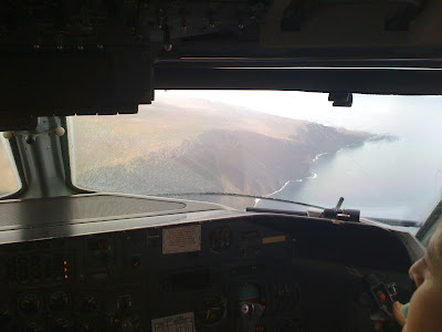
After a short and quick 15 minute turn in JHM/PHJH, we depart for HNL/PHNL.
We reach our cruising altitude for the 32 minute flight back. Nothing to look at during this flight because of the clouds below us at FL050. On this flight, we fly in the channel north of the island of Lanai (LNY/PHNY) and south of Molokai. Normally it's a great flight to see the middle islands, not today.
At 30 miles out we call the field as we are cleared down to FL025. The clouds around Honolulu are now mainly over the mountains with some high broken to overcast over the south shore. HNL tower clears us for the visual on the "channel approach" which is we fly towards the entrance to Pearl Harbor then make a visual right turn from base to runway 8L. This approach is favored by all the interisland pilots because of its close proximity to the taxiways that lead to the interisland ramp.
We start our turn to final for 8L. Since HNL is a shared field with Hickam/Pearl Harbor Air Base (combined field now for the military), it affords some great views of Pearl with the Arizona Memorial and the USS Missouri in the distance and the Hickam flight line.
Showers again over Keehi Lagoon 2 miles away but noticeably HNL had some rain as to the sheen of water on 8L as we continue our landing.
After the landing, we get nailed by the rain that we saw as we taxied in to the gate.
20 minutes later were on the go again heading back to MKK and LNY.
WOW! what a difference 20 minutes make. The sun is now shining over the south shore of Honolulu. The tourist are getting their money's worth now that the rain has passed and the beaches are sunny. Ala Moana Beach Park is visible as the long stretch of sandy beach in the foreground with famous Diamond Head in the distance.
This leg goes to Molokai first, and since I covered that in Part one of this blog, I'm skipping to Lanai.
The approach to the airport starts on the south side of the island. The first thing you notice is the cliffs on the south shore. Rising 500 feet above the sea, it's both beautiful and imposing.
LNY was originally owned by the Dole Company and was nicknamed for many years "The Pineapple Island". That's because of most of the flat level land from the south shore cliffs to the town of Lanai was covered with Pineapple fields. A good portion of the pineapples that were shipped around the world came from Lanai. With changing times, labor cost for growing pineapples became more expensive, so after the fields had grown their last crop, they were left vacant. David Murdoch purchased the island from Dole and now his company, Castle & Cooke, runs the island and has developed two world class resorts to replace agriculture as the sole source of island income for its residents who were left without jobs when Dole pulled out of the island.

On glideslope...Lanai is one of those fields that you can have strong winds to low ceiling and visibility in a rather short time. The airport sits about 600 feet ASL and because of the mountains in the north, east and west sides, can cause clouds to "sit" in what we refer to as "the bowl".
Welcome to bright and sunny Lanai!
We depart Lanai and within a short 30 minute flight were back in Honolulu. This is the approach to 4R which takes us over 8R/26L better known as the "Reef Runway".
After landing we taxi to via "Bravo" taxiway to cross 8L/26R at "Golf". We wait while an American Airlines 757 lands. just behind the tail taxing up to the interisland terminal is Hawaiian Airlines new Airbus. Just one more round trip and I'm done for the day.
Hope you enjoyed this little series. Thanks for reading!


